The post Scotland’s World Heritage Sites! appeared first on ScotClans | Scottish Clans.
]]>If you were not aware UNESCO is the United Nations Educational, Scientific and Cultural Organization and they are in charge of running the World Heritage Programme. The programme catalogues, names, and conserves sites of outstanding cultural or natural importance to the common heritage of humanity. There are currently 1008 sites listed across 161 countries including such wonders as the Great Wall of China, Angkor Wat in Cambodia, Canadian Rocky Mountain Parks, Statue of Liberty in the USA, Uluru in Australia and many, many more.
Now let’s take a look at what Scotland has to offer, starting with the most recent addition…

Forth Bridge
The Forth Bridge is one of 3 crossings over the Firth of Forth beginning just west of Edinburgh over to Queensferry. Alongside it are the Forth Road Bridge and the yet to be completed Queensferry Crossing. It is a fantastic example of single cantilever bridge and was the longest such bridge in the world until 1917 when the Quebec Bridge in Canada was completed but it continues to be world’s second-longest single cantilever span. It is 8,094 feet in length, and the double track is elevated 150 feet above the water level at high tide. The weight of the bridge superstructure was 50,513 long tons, including the 6.5 million rivets used. The bridge also used 640,000 cubic feet of granite.
Prior to the construction of the bridge the only way across the Forth was by ferry. In 1806 it was proposed that a tunnel was dug under the Forth to provide a crossing route and in 1818 James Anderson produced a design for a three-span suspension bridge close to the site of the present one but that proved to not move forward any further than a design. Thomas Bouch became involved in 1871 and designed a suspension bridge that would have crossed the Forth at almost the same point as the present bridge, and after careful verification, work started in 1878 on a pier at Inchgarvie. However following the Tay Bridge disaster in 1879, all confidence in Bouch quickly evaporated. The public inquiry into the disaster found the Tay Bridge to be “badly designed, badly constructed and badly maintained,” with Bouch being “mainly to blame” for the defects in construction and maintenance and “entirely responsible” for the defects in design. Bouch’s design was formally abandoned on 13 January 1881, and Sir John Fowler, W. H. Barlow and T. E. Harrison, consulting engineers to the project, were invited to give proposals for a bridge. It was two of these men, the English engineers, Sir John Fowler and Sir Benjamin Baker, that designed the bridge we know and love today.

In April 1883, construction of a landing stage at Inchgarvie commenced. Extensive preparations took place to prepare the are for the bridge and included removal of an old coastguard station at the Fife end to make way for the north-east pier, a steep hillside had to be terraced on the Queensferry end and wooden huts and shops for the workmen were put up in the area, a cable was laid across the Forth to allow telephone communication between the centres at Queensferry, Inchgarvie, and Fife. Near the shore a sawmill and cement store were erected, and a substantial jetty around 2,100 feet long was started early in 1883 and sidings were built to bring railway vehicles among the shops, and cranes set up to allow the loading and movement of material delivered by rail. On Inchgarvie extant buildings, including fortifications built in the 15th century, were roofed over to increase the available space, and the rock at the west of the island was cut down to a level 7 feet above high water, and a seawall was built to protect against large waves.
At its peak, approximately 4,600 workers were employed in its construction, it used 55,000 tonnes of steel and 140,000 cubic yards of masonry including Aberdeen granite, Arbroath rubble, sand and timber the marvel of engineering was completed after 6 hard years in December 1889. The first complete crossing took place on 24 February, when a train consisting of two carriages carrying the chairmen of the various railway companies involved made several crossings. The bridge was officially opened on 4 March 1890 by the Prince of Wales, later King Edward VII, who drove home the last rivet, which was gold plated and suitably inscribed. The key for the official opening was made by Edinburgh silversmith John Finlayson Bain, commemorated in a plaque on the bridge.

Something interesting happened between competing railway operators following the opening of the bridge. Previously a trip from London to Aberdeen would have taken around 13 hours up the west coast lines(from Euston and using the London and North Western Railway and Caledonian Railway on a west coast route), with the opening of the east coast lines(starting from King’s Cross up to the Great Northern, North Eastern and North British railways east line) the two different routes began to unofficially race reducing the journey time to about 8½ hours on the overnight runs. When the public interest in these ‘races’ began to subside the journey pulled back to an average time of around 10 hours, still a big improvement.
In the First World War British sailors would time their departures or returns to the base at Rosyth by asking when they would pass under the bridge. This practice continued at least up to the 1990s.
The first German air attack on Britain in the Second World War took place over the Forth Bridge, six weeks into the war, on 16 October 1939. Although known as the “Forth Bridge Raid”, the bridge was not the target and not damaged. The target of the attack was shipping from the Rosyth naval base in the Forth, close to the bridge.
Network Rail plans to add a visitor centre to the bridge, which would include a viewing platform on top of the North Queensferry side, or a bridge climbing experience to the South Queensferry side.

St Kilda
St Kilda is an isolated archipelago 64 kilometres west-northwest of North Uist in the North Atlantic Ocean. It contains the westernmost islands of the Outer Hebrides of Scotland. The largest island is Hirta, whose sea cliffs are the highest in the United Kingdom; three other islands (Dùn, Soay and Boreray) were also used for grazing and seabird hunting.
St Kilda may have been permanently inhabited for at least two millennia, the population probably never exceeding 180 but the entire remaining population was evacuated from Hirta (the only inhabited island) in 1930. It became one of Scotland’s six World Heritage Sites in 1986 and is one of the few in the world to hold joint status for its natural and cultural qualities, an honour the islands share with internationally important sites such as Machu Picchu in Peru, Mount Athos in Greece and the Ukhahlamba/Drakensberg Park in South Africa.. Parties of volunteers work on the islands in the summer to restore the many ruined buildings that the native St Kildans left behind. They share the island with a small military base established in 1957.
One of the primary themes of life on St Kilda for the natives was that of isolation. Separated by distance and weather, the natives knew little of mainland and international politics. After the Battle of Culloden in 1746, it was rumoured that Bonnie Prince Charlie and some of his senior Jacobite aides had escaped to St Kilda. An expedition was launched, and in due course British soldiers were ferried ashore to Hirta. They found a deserted village, as the St Kildans, fearing pirates, had fled to caves to the west. When the St Kildans were persuaded to come down, the soldiers discovered that the isolated natives knew nothing of the prince and had never heard of King George II either.
Even in the late 19th century, the islanders could only communicate with the rest of the world by either lighting a bonfire on the summit of Conachair and hoping a passing ship might see it, or by using the “St Kilda mailboat”. This was the invention of John Sands, who visited in 1877. During his stay, a shipwreck left nine Austrian sailors marooned there, and by February supplies were running low. Sands attached a message to a lifebuoy salvaged from the Peti Dubrovacki and threw it into the sea. Nine days later it was picked up in Birsay, Orkney, and a rescue was arranged. The St Kildans, building on this idea, would fashion a piece of wood into the shape of a boat, attach it to a bladder made of sheepskin, and place in it a small bottle or tin containing a message. Launched when the wind came from the north-west, two-thirds of the messages were later found on the west coast of Scotland or, less conveniently, in Norway.
Above and beyond the isolation the life of a St Kildan was very different for several other reasons. Their diet was heavily restricted by what could be farmed or hunted on the island. The islanders kept sheep and a few cattle and were able to grow a limited amount of food crops such as barley and potatoes and they generally shied away from the fishing that you would expect from such an area due to the unpredictable nature of the seas around the island. Instead the mainstay of their diet was the profusion of island birds, especially gannet and fulmar. They harvested the eggs and young birds and ate both fresh and cured. Adult puffins were also caught by the use of fowling rods. These fowling activities involved considerable skills in climbing, especially on the precipitous sea stacks. An important island tradition involved the ‘Mistress Stone’, a door-shaped opening in the rocks north-west of Ruival over-hanging a gully. Young men of the island had to undertake a ritual there to prove themselves on the crags and worthy of taking a wife.

Another important aspect of St Kildan life was the daily ‘Parliament’. This was a meeting held in the street every morning and attended by all the adult males during the course of which they would decide upon the day’s activities. No one led the meeting, and all men had the right to speak.
On 29 August 1930, the residents of the island were removed to Morvern on the Scottish mainland at their own request. Numerous factors led to the evacuation of St Kilda. The islands’ inhabitants had existed for centuries in relative isolation until tourism and the presence of the military in World War I disconnected the islanders from the way of life that had allowed their forebears to survive in this unique environment. After World War I most of the young men left the island, and the population fell from 73 in 1920 to 37 in 1928. After the death of four men from influenza in 1926 there was a succession of crop failures in the 1920s. Investigations by Aberdeen University into the soil where crops had been grown have shown that there had been contamination by lead and other pollutants, caused by the use of sea bird carcasses and peat ash in the manure used on the village fields. The dwindling population and the isolation from medical care led to the islanders eventually abandoning St Kilda.
In 1931 St Kilda was sold to the Marquess of Bute, a keen ornithologist. He bequeathed them to The National Trust for Scotland in 1957.

New Lanark
New Lanark is a village on the River Clyde, just over a mile from Lanark, in Lanarkshire, and some 24 miles from Glasgow. It was founded in 1786 by David Dale, who built cotton mills and housing for the mill workers. Dale built the mills there in a brief partnership with the English inventor and entrepreneur Richard Arkwright to take advantage of the water power provided by the only waterfalls on the River Clyde. Under the ownership of a partnership that included Dale’s son-in-law, Robert Owen, a Welsh philanthropist and social reformer, New Lanark became a successful business and an epitome of utopian socialism as well as an early example of a planned settlement and so an important milestone in the historical development of urban planning.
The New Lanark cotton mills were founded in 1786 by David Dale although he sold the mills, lands and village in the early 19th century for £60,000, payable over 20 years, to a partnership that included his son-in-law Robert Owen. Owen, who became mill manager in 1800, was an industrialist who carried on his father-in-law’s philanthropic approach to industrial working and who subsequently became an influential social reformer. In Owen’s time some 2,500 people lived at New Lanark, many from the poorhouses of Glasgow and Edinburgh. Although not the grimmest of mills by far, Owen found the conditions unsatisfactory and resolved to improve the workers’ lot. He paid particular attention to the needs of the 500 or so children living in the village and working at the mills, and opened the first infants’ school in Britain in 1817.
The mills thrived commercially, but Owen’s partners were unhappy at the extra expense incurred by his welfare programmes. Unwilling to allow the mills to revert to the old ways of operating, Owen bought out his partners. In 1813 the Board forced an auction, hoping to obtain the town and mills at a low price but Owen and a new board, that was sympathetic to his reforming ideas, won out.
New Lanark became celebrated throughout Europe, with many leading royals, statesmen and reformers visiting the mills. They were astonished to find a clean, healthy industrial environment with a content, vibrant workforce and a prosperous, viable business venture all rolled into one. Owen’s philosophy was contrary to contemporary thinking, but he was able to demonstrate that it was not necessary for an industrial enterprise to treat its workers badly to be profitable. Owen was able to show visitors the village’s excellent housing and amenities, and the accounts showing the profitability of the mills.

In 1825, control of New Lanark passed to the Walker family when Owen left Britain to start settlement of New Harmony in the US. The Walkers managed the village until 1881, when it was sold to Birkmyre and Sommerville and the Gourock Ropeworks. They and their successor companies remained in control until the mills closed in 1968. The town and the industrial activity had been in decline before then, but after the mills closed migration away from the village accelerated, and the buildings began to deteriorate. In 1970 the mills, other industrial buildings and the houses used by Dale and Owen were sold to Metal Extractions Limited, a scrap metal company. In 1974 the NLCT (now the NLT) was founded to prevent demolition of the village. A compulsory purchase order was used in 1983 to recover the mills and other buildings from Metal Extractions after a repairs notice had been served in 1979. This was because of the state of repair of the buildings despite their listing as historic buildings that required their legal preservation in 1971. By 2005 most of the buildings had been restored and the village has become a major tourist attraction.
It has been estimated that over 400,000 people visit the village each year and about 200 people currently live in New Lanark. Considerable attention has been given to maintaining the historical authenticity of the village. No television aerials or satellite dishes are allowed in the village, and services such as telephone, television and electricity are delivered though buried cables. To provide a consistent appearance all external woodwork is painted white, and doors and windows follow a consistent design. Householders used to be banned from owning dogs, but this rule is no longer enforced.

Edinburgh’s Old & New Town
The Old Town is he name given to the oldest part of Scotland’s capital, and is an area that has retained much of the medieval street plan and many of the reformation era buildings. The New Town is the name given to the are just north of the Old Town, built between 1767 and around 1850, which retains much of the original neo-classical and Georgian period architecture and is considered a masterpiece of city planning. Together these two areas of the city form one World Heritage Site.
The Old Town makes up the heart of Edinburgh and has done since the beginnings of the city of Edinburgh. The Royal Mile is at the heart of the area and makes up it’s main artery, running from Edinburgh Castle all the way down to Holyrood Palace. Narrow closes (alleyways), often no more than a few feet wide, lead steeply downhill to both north and south of the main spine which runs west to east.n addition to the Royal Mile, the Old Town may be divided into various areas, namely from west to east: West Port, the old route out of Edinburgh to the west, Grassmarket, the area to the south-west, Edinburgh Castle, The Cowgate, the lower southern section of the town, Canongate, a name correctly applied to the whole eastern district, Holyrood, the area containing Holyrood Palace and Holyrood Abbey, Croft-An-Righ, a group of buildings north-east of Holyrood. Notable buildings in the Old Town include St. Giles’ Cathedral, the General Assembly Hall of the Church of Scotland, the National Museum of Scotland, the Old College of the University of Edinburgh and the Scottish Parliament Building.
Due to the space restrictions imposed by the narrowness of the “tail” the Old Town became home to some of the earliest “high rise” residential buildings. Multi-story dwellings were the norm from the 16th century onwards. A census 0f 1792 put the Old Town and Canongate population at around 30,000 residents. As the population was for a long time reluctant to build outside the defensive wall, the need for housing grew and hence the buildings became higher and higher. Many of these buildings were destroyed in the Great Fire of Edinburgh (1824); the rebuilding of these on the original foundations led to changes in the ground level and the creation of many passages and vaults under the Old Town. The construction of new streets including North Bridge and South Bridge in the 18th century also created underground spaces, such as the Edinburgh Vaults below the latter. Traditionally buildings were less dense in the eastern, Canongate, section. This area underwent major slum clearance and reconstruction in the 1950s, thereafter becoming an area largely of Council housing. Further Council housing was built on the southern fringe of the Canongate in the 1960s and 1970s in an area generally called Dumbiedykes. From 1990 to 2010 major new housing schemes appeared throughout the Canongate. These were built to a much higher scale than the traditional buildings and have greatly increased the population of the area.

The idea of a New Town was first suggested in the late 17th century when the Duke of Albany and York (later King James VII and II), when resident Royal Commissioner at Holyrood, encouraged the idea of having an extended regality to the north of the city and a North Bridge. The decision to construct a New Town was taken by the city fathers, after overcrowding inside the Old Town city walls reached breaking point and to prevent an exodus of wealthy citizens from the city to London.[2] The Age of Enlightenment had arrived in Edinburgh, and the outdated city fabric did not suit the professional and merchant classes who lived there. Lord Provost George Drummond succeeded in extending the boundary of the Royal Burgh to encompass the fields to the north of the Nor Loch, the heavily polluted body of water which occupied the valley immediately north of the city. A scheme to drain the Loch was put into action, although the process was not fully completed until 1817. Crossing points were built to access the new land; the North Bridge in 1772, and the Earthen Mound, which began as a tip for material excavated during construction of the New Town. The Mound, as it is known today, reached its present proportions in the 1830s.
As the successive stages of the New Town were developed, the rich moved northwards from cramped tenements in narrow closes into grand Georgian homes on wide roads. However, the poor remained in the Old Town.
The street names applied to the New Town are something of interest when investigated. The principal street was named George Street, after the king at the time, George III. Queen Street was to be located to the north, named after his wife, and St. Giles Street to the south, after the city’s patron saint. St. Andrew’s Square and St. George’s Square, located at either end of George Street, were the names chosen to represent the union of Scotland and England. The idea was continued with the smaller Thistle Street (for Scotland’s national emblem) between George Street and Queen Street, and Rose Street (for England’s emblem) between George Street and Princes Street.
King George rejected the name St. Giles Street as St Giles was known as the patron saint of lepers and the name was also connected with a slum area on the edge of the City of London. It was therefore renamed Princes Street after his sons. The name of St. George’s Square was changed to Charlotte Square, after the Queen, to avoid confusion with the existing George Square on the South Side of the Old Town. The westernmost blocks of Thistle Street were renamed Hill Street and Young Street, making Thistle Street half the length of Rose Street. The three streets completing the grid, Castle, Frederick and Hanover Streets, were named for the view of the castle, King George’s father Frederick, and the name of the royal family respectively.
The New Town was envisaged as a purely residential suburb but it did not take long for the commercial potential of the site to be realised. Shops were soon opened on Princes Street, and during the 19th century the majority of the townhouses on that street were replaced with larger commercial buildings.
Occasional piecemeal redevelopment continues to this day, though most of Queen Street and Thistle Street, and large sections of George Street, Hanover, Frederick and Castle Streets, are still lined with their original late 18th century buildings. Very large sections of the Second New Town, built from the early 19th century are also still exactly as built.

The Antonine Wall
The lesser known brother to England’s Hadrians Wall, the Antonine Wall is a stone and turf fortification built by the Romans across what is now the Central Belt of Scotland, between the Firth of Forth and the Firth of Clyde. It spanned approximately 39 miles and was about 3 metres high and 5 metres wide.
The Antonine wall was built from turf on a stone foundation, and the stone foundations and wing walls of the original forts demonstrate that the original plan was to build a stone wall similar to Hadrian’s Wall, but this plan was at sometime abandoned. The Romans initially planned to build forts every 6 miles, but this was soon revised to every 2 miles, resulting in a total of nineteen forts along the wall. The best preserved but also one of the smallest forts is Rough Castle Fort. In addition to the forts, there are at least 9 smaller fortlets, very likely on Roman mile spacings, which formed part of the original scheme, some of which were later replaced by forts.
Roman Emperor Antoninus Pius ordered the construction of the Antonine Wall around 142 and took around 12 years to complete. The wall was intended as a replacement for Hadrians Wall, 99 miles south, and to extend the borders and dominance of the Roman Empire becoming the new frontier of Britannia.
The wall was abandoned only eight years after completion, when the Roman legions withdrew to Hadrian’s Wall in 162, and over time reached an accommodation with the Brythonic tribes of the area whom they fostered as the buffer states which would later become “The Old North”. After a series of attacks in 197, Emperor Septimius Severus arrived in 208 to secure the frontier, and oversee repairs to the wall. Although this re-occupation only lasted a few years, the wall is sometimes referred to by later Roman historians as the Severan Wall.
Today the remains of the wall and several of the forts can still be seen along it’s original route, and due to it travelling across such a vast area it’s fairly easy to visit and view sections, although it may take a awhile to take in the whole monument.

The Heart of Neolithic Orkney
The Heart of Neolithic Orkney refers to a group of Neolithic monuments found on the Mainland, one of the islands of Orkney, and the name was adopted by UNESCO when it proclaimed these sites as a World Heritage Site in 1999.
The grouping currently consists of four important sites found in and around this are; Maeshowe, Standing Stones of Stenness, Ring of Brodgar and Skara Brae.

Maeshowe is a Neolithic chambered cairn and passage grave that was likely built around 2800 BCE.
The mound encasing the tomb is 35m in diameter and rises to a height of 7.3m. Surrounding the mound, at a distance of 15m to 21m is a ditch up to 14m wide. The grass mound hides a complex of passages and chambers built of carefully crafted slabs of flagstone weighing up to 30 tons. It is aligned so that the rear wall of its central chamber held up by a bracketed wall,is illuminated on the winter solstice.
Maeshowe is the largest burial cairn of it’s class and gives it’s name to other such chambered cairns, which are limited to Orkney. It is believed a monument such as this, built at the time it was, would have taken a considerable amount of effort to build. Estimates put it somewhere in the area of 100,000 man-hours. It represents a significant example of Neolithic craftsmanship.

The Standing Stones of Stenness, another Neolithic monument, are found 5 miles northeast of Stromness on the mainland of Orkney and may be the oldest henge site in the British Isles.
The monument is made up of thin slabs, approximately 300 mm (12 in) thick with sharply angled tops. Four, up to about 5m high, were originally elements of a stone circle of up to 12 stones, laid out in an ellipse about 32m diameter on a levelled platform of 44m diameter, surrounded by a ditch. Based on radiocarbon dating, it is thought that work on the site had begun by 3100 BC.
Traditions involving the stones survived for centuries, right up to the 18th century. One tradition involved a particular stone, known as the “Odin Stone” which stood in the field to the north of the henge,was pierced with a circular hole, and was used by local couples for plighting engagements by holding hands through the gap.
Unfortunately this stone was destroyed in late 1814. Captain W. Mackay, a recent immigrant to Orkney who owned farmland in the vicinity of the stones, decided to remove them on the grounds that local people were trespassing and disturbing his land by using the stones in rituals. He started by smashing the Odin Stone. This caused outrage in the locals and they managed to stop him causing any more damage, but only after he had destroyed one other stone and toppled another. The toppled stone was re-erected in 1906 along with some inaccurate reconstruction inside the circle.

The Ring of Brodgar (or Brogar, or Ring o’ Brodgar) is another Neolithic henge and stone circle found about 6 miles north-east of Stromness and is the northern most example of a henge found in Britain.
Brodgar is a striking exception of a henge containing a stone circle, ranking with Avebury (and to a lesser extent Stonehenge) among the greatest of such sites. The site has resisted attempts at scientific dating and the monument’s age remains uncertain. It is generally thought to have been erected between 2500 BC and 2000 BC, and was, therefore, the last of the great Neolithic monuments built on the Ness.

Skara Brae is a stone-built Neolithic settlement, located on the Bay of Skaill on the west coast of Mainland which was occupied from roughly 3180 BCE–2500 BCE. It makes up Europe’s most complete Neolithic village older than both Stonehenge and the Great Pyramids, and is often called the “Scottish Pompeii” because of its excellent preservation.
In the winter of 1850, a severe storm hit Scotland, causing widespread damage and over 200 deaths. In the Bay of Skaill, the storm stripped the earth from a large irregular knoll known as “Skerrabra”. When the storm cleared, local villagers found the outline of a village, consisting of a number of small houses without roofs.
William Watt of Skaill, the local laird, began an amateur excavation of the site, but after four houses were uncovered, but the work was abandoned in 1868. The site remained undisturbed until 1913, when during a single weekend the site was plundered by a party with shovels who took away an unknown quantity of artifacts. In 1924, another storm swept away part of one of the houses and it was determined the site should be made secure and more seriously investigated. The job was given to University of Edinburgh’s Professor Vere Gordon Childe.
The houses used earth sheltering, being sunk into the ground. It is believed they were sunk into mounds of pre-existing prehistoric domestic waste known as middens. The midden provided the houses with a small degree of stability and also acted as insulation against Orkney’s harsh winter climate. On average, the houses measure 40 square metres in size with a large square room containing a stone hearth used for heating and cooking. Given the number of homes, it seems likely that no more than fifty people lived in Skara Brae at any given time.
The dwellings contain a number of stone-built pieces of furniture, including cupboards, dressers, seats, and storage boxes and each dwelling even included a primitive form of a toilet.
The Grooved Ware People, a distinctive form of pottery found around all the sites in the Neolithic Heart of Orkney, who built Skara Brae were primarily pastoralists who raised cattle and sheep. It was originally believed that the inhabitants did not practice agriculture, but excavations in 1972 unearthed seed grains from a midden suggesting that barley was cultivated.
This pastoral lifestyle is in sharp contrast to some of the more exotic interpretations of the culture of the Skara Brae people. Euan MacKie, a British archaeologist and anthropologist, suggested that Skara Brae might be the home of a privileged theocratic class of wise men who engaged in astronomical and magical ceremonies at nearby Ring of Brodgar and the Standing Stones of Stenness. Doubt has been cast on this interpretation as there is no archaeological evidence to back it up.
The post Scotland’s World Heritage Sites! appeared first on ScotClans | Scottish Clans.
]]>The post How the Clans Inspired Game of Thrones appeared first on ScotClans | Scottish Clans.
]]> It’s a well-known and begrudgingly accepted fact that Game of Thrones author George R.R. Martin loves to kill off central characters. In episode nine of the third season of the television series based on the books, three deaths in the space of mere minutes provoked an excessive amount of mortified outcry in almost every media outlet imaginable a few weeks ago. Such shocked reactions are nothing new to Martin – ever since the third book was published a decade ago, he’s been receiving exclamatory emails and letters from heartbroken readers about the disastrous Stark-Tully-Frey union. In a nutshell, three members of the much-loved but ill-fated Stark family and hundreds of Stark bannermen were slaughtered at a wedding, decisively snuffing out the King of the North’s claim to the throne of Westeros.
After heartbreakingly accidentally reading a tiny spoiler via a newspaper, I finally watched the final two episodes of season three a week after the episodes were released. Once the shock subsided and I finally stopped weeping, I was very intrigued to discover that Martin based the fateful ‘Red Wedding’ on two specific events from Scottish clan history. In an interview with EW, Martin said: “No matter how much I make up, there’s stuff in history that’s just as bad, or worse.”
The first event dates back to the fifteenth century, when Clan Douglas were one of the most powerful families in lowland Scotland. Rival families including Clan Crichton felt the Douglases were far too strong and capable of upsetting the delicate power-balance in Scotland at that point. In 1440 King James II was only ten years of age, and the ambitious and influential clan chief William Douglas could have easily gained control of the throne. So Clan Crichton, with the help of Alexander Livingston of Callendar, set out to extinguish the Douglas threat.
In 1440 Sir William Crichton, custodian of Edinburgh Castle, invited William Douglas and his younger brother David to dine with the young king; with the siblings suspecting nothing as the evening proceeded. Near the end of the dinner, a black bull’s head (the symbol of death) was placed on the table by a servant. The two brothers were then seized and dragged out to Castle Hill at the top of the Royal Mile. They were given a mock-trial and accused of various crimes including high treason, before being lead to the headman’s block where they both met a grisly demise with the swing of the executioners axe.

A depiction of the Black Dinner, an inspiration for the Red Wedding
This event came to be known as the ‘Black Dinner’, and just as in Thrones, a family were murdered after the unspoken laws and customs of hospitality were breached. Unsurprisingly the rest of Clan Douglas were quick to retaliate, laying siege to Edinburgh Castle and causing considerable damage. Perceiving the danger, Crichton surrendered the castle to King James who was then given the title of Lord Crichton. This was a politically astute move as challenging the decision would have meant challenging the king himself and left them fighting an unwinnable war against much of Scotland.
The discussion on the laws of hospitality that frequent the final two episodes also eerily draw from the events of the Massacre of Glencoe, which I blogged about earlier this year. In the final episode of the series, Bran speaks of a Lord who killed guests beneath his roof, saying “it’s something the Gods cannot forgive“. In 1692 32 Clan MacDonald members were murdered by Clan Campbell on direct orders from the crown, after providing accommodation to Campbell clansmen for the previous two weeks. The massacre was considered especially awful as it was considered ‘slaughter under trust’, and is still commemorated to this day.
I’m also convinced that Martin based his family/house structures in the series on the Scottish clan system. Every Thrones house has a coat of arms, words, leader, seat and region; just as each clan has their own crest, motto, chief, seat and region. I’ve made a comparison below between House Lannister from the series, and Clan MacGregor:
 House Lannister
Words - Hear Me Roar!
Current Leader - Joffrey Baratheon
King of the Seven Kingdoms
Seat - Casterley Rock
Region - The Westerlands
 Clan MacGregor
Motto – ‘S rioghal mo dhream (My race is royal)
Current Chief - Sir Malcolm MacGregor of MacGregor
The 7th baronet of Lanrick and Balquhidder
Seat - Bannatyne
Region - Argyll and Perthshire

The clans of Scotland have certainly captured the imagination of Martin, hundreds of years after these fateful events occurred. Like millions of others around the world, I sit with bated breath awaiting the next installment in the Game of Thrones series. Just in case you’re wondering, you can check here how many weeks and days are remaining by clicking here!
The post How the Clans Inspired Game of Thrones appeared first on ScotClans | Scottish Clans.
]]>The post Ice Age Scotland appeared first on ScotClans | Scottish Clans.
]]>The Ice Age was more than just a never ending cold, or ice building up and flowing across the landscape; it carved that very landscape, obliterating what went before and providing a new canvass for nature to re-conquer once the glaciers finally melted. The geology of Scotland in places is billions of years old, and for the most part hundreds of millions of years old; but it has been sculpted over the last two million by repeated glacial episodes, the last of which began around 30,000 years ago and finally ended 10,000 years ago. But, what causes these events and what legacy have they left us?
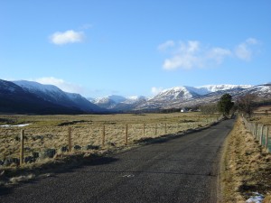
Glen Doll in Angus – A landscape carved by Ice
The principal reasons that the earth experiences enhanced ice age events periodically are astronomical; and collectively termed the Milankovitch Cycles (named after the Serbian scientist, Milutin Milanković, who first made the connection). We assume that the planet meanders through the vastness of space in a uniform manner, fixed in place: but not so. Over time periods we cannot comprehend the earth wobbles about and shifts its patterns of orbit and rotation; and does so cyclically, repeating the pattern across the ages.
Each cycle has its extremes, and can individually trigger enhanced ice growth; but they peak at differing time intervals, and so it’s only when they click together that the results can be truly spectacular. They’re not the only factors involved, others include the strength or non-existence of the Gulf Stream, plate tectonics and mountain building, and many more – and to be honest we really don’t know how it all connects together. Still, 30,000 years ago, the Milankovitch cogwheels clicked into place and the Gulf Stream turned off; resulting in the rapid build up of ice at the poles and the southward advance of the polar front: the summer limit of pack-ice.
Initially as the polar front moved southward, Scotland experienced extremely cold winters, somewhat like Canada today; resulting in glacier ice forming in the Northwest Highlands, the Nevis Range, the Cairngorms and Lochnagar; plus winter sea ice probably reached as far as the Shetland Islands. This is colder than we’ve experienced in the last 10,000 years, but there was no respite and the mercury continued to drop. Ice ages don’t happen because of cold winters, they happen because of cold summers, where the ice and snow from the previous season doesn’t melt and it builds up, layer upon layer, until it starts flowing under its own weight towards the sea via a path of least resistance. The glaciers then pool in lower ground.
It would only take a couple of thousand years to go from small glaciers in the mountains to ice caps forming in places like Rannoch Moor, Royal Deeside and the Great Glen. Around 25,000 years ago large glaciers, the like we’d associate with Alaska today would be flowing steadily down our main valleys, to perhaps a thickness of 2000ft in the upland areas. By now there is glacier ice in the Southern Uplands, the Lake District, Yorkshire and Snowdonia; and large ice flows streaming through the Central Belt mainly towards the North Sea via Strathmore and the Forth Valley.
The glacial maximum came around 18,000 years ago, when the polar front which today is to the north of Iceland reached to Portugal. Scotland was now buried under an ice-sheet over 4000ft thick in places: akin to Greenland today; and it was small in comparison. The whole of Scandinavia was buried under a much thicker dome centered over the Baltic Sea, and North America groaned under the vast weight of the Laurentide Ice Sheet, which may have been 10,000ft thick, and was over half as big again as the Antarctic sheet today. The result of all this water locked away as ice was a severe drop in sea levels: over 400ft lower than today. The North Sea didn’t was a meadowland, grazed by mammoths and other lost fauna during the short summer season. It is possible that people followed the game on to the plains; but we also know that the population of Europe was very low, and forced into cluster ‘refuges’.
From around 18,000 years ago the earth slowly warmed again and the cogs came out of sync; and by 13,000 years ago the British ice sheet, which had stretched to the English Midlands, and covered most of Ireland had gone. The ice itself had carved out a new landscape, digging deep into the rock as it ground its way to the sea. The picturesque fjord landscape of the west coast, deep valleys like Glencoe and Glen Muick, the rounded hills of the Southern Uplands and the sharp ridges of the Cuillin of Skye: all sculpted out of the bedrock by the sheer power of the glaciers. The melting of that ice had no less a dramatic effect either.
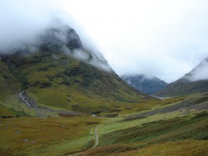
Glencoe – A typical U-Shaped valley
Most of the Highland valleys and all of the Lowlands are blanketed in debris either left directly by retreating ice, or washed out by meltwaters. Torrential flooding and reworking of sediment created terraces, gravel fans and deep, sandy deposits; in other places the retreating ice can be mapped by way of the unique landforms left behind, like the horseshoe shaped moraines dumped at the front of the glacier. Only the far northwest, where the landscape was heavily scoured, saw little deposition – giving us a glimpse of the immediate post glacial world of Scotland 13,000 years ago. But everywhere you look you will find evidence of Scotland’s Ice Age: from Edinburgh’s Royal Mile to the deep lochs of the Great Glen; and from the macro to the micro.
Global temperatures dropped again around 11,500 years ago, and there was further ice growth in the Highlands, but by 10,000 years ago the last of the glaciers had melted; and thus it has remained. A new world emerged from the grip of the big freeze, great rivers now flow where ice once ruled, and soon forests and grasslands came to dominate. The sea also rose, rapidly and to levels higher than today. This is thanks to a phenomenon where the land, having been compressed by the sheer weight of the ice, rebounds, but at a slower rate than the sea. So, relative to one another the sea reaches a certain height, and then the land slowly rises out of it. And all around our coast are archaic cliffs and raised beaches: testament to an older shoreline when sea levels were over 100ft higher. Scotland continues to rise.
For 10,000 years humankind has basked in the warmth of the current inter-glacial and flourished like never before in our history. But, eventually the Milankovitch cogwheels will click once more, and Scotland along with half the globe will be plunged again into the abyss of an Ice Age.
This article was written by David McNicoll, the owner of Vacation Scotland; a travel company specialising in tours and vacation packages to Scotland. If you are interested in exploring Scotland’s landscapes, please contact them by clicking their website – www.vacationscotland.biz
The post Ice Age Scotland appeared first on ScotClans | Scottish Clans.
]]>