The post Scotland’s World Heritage Sites! appeared first on ScotClans | Scottish Clans.
]]>If you were not aware UNESCO is the United Nations Educational, Scientific and Cultural Organization and they are in charge of running the World Heritage Programme. The programme catalogues, names, and conserves sites of outstanding cultural or natural importance to the common heritage of humanity. There are currently 1008 sites listed across 161 countries including such wonders as the Great Wall of China, Angkor Wat in Cambodia, Canadian Rocky Mountain Parks, Statue of Liberty in the USA, Uluru in Australia and many, many more.
Now let’s take a look at what Scotland has to offer, starting with the most recent addition…

Forth Bridge
The Forth Bridge is one of 3 crossings over the Firth of Forth beginning just west of Edinburgh over to Queensferry. Alongside it are the Forth Road Bridge and the yet to be completed Queensferry Crossing. It is a fantastic example of single cantilever bridge and was the longest such bridge in the world until 1917 when the Quebec Bridge in Canada was completed but it continues to be world’s second-longest single cantilever span. It is 8,094 feet in length, and the double track is elevated 150 feet above the water level at high tide. The weight of the bridge superstructure was 50,513 long tons, including the 6.5 million rivets used. The bridge also used 640,000 cubic feet of granite.
Prior to the construction of the bridge the only way across the Forth was by ferry. In 1806 it was proposed that a tunnel was dug under the Forth to provide a crossing route and in 1818 James Anderson produced a design for a three-span suspension bridge close to the site of the present one but that proved to not move forward any further than a design. Thomas Bouch became involved in 1871 and designed a suspension bridge that would have crossed the Forth at almost the same point as the present bridge, and after careful verification, work started in 1878 on a pier at Inchgarvie. However following the Tay Bridge disaster in 1879, all confidence in Bouch quickly evaporated. The public inquiry into the disaster found the Tay Bridge to be “badly designed, badly constructed and badly maintained,” with Bouch being “mainly to blame” for the defects in construction and maintenance and “entirely responsible” for the defects in design. Bouch’s design was formally abandoned on 13 January 1881, and Sir John Fowler, W. H. Barlow and T. E. Harrison, consulting engineers to the project, were invited to give proposals for a bridge. It was two of these men, the English engineers, Sir John Fowler and Sir Benjamin Baker, that designed the bridge we know and love today.

In April 1883, construction of a landing stage at Inchgarvie commenced. Extensive preparations took place to prepare the are for the bridge and included removal of an old coastguard station at the Fife end to make way for the north-east pier, a steep hillside had to be terraced on the Queensferry end and wooden huts and shops for the workmen were put up in the area, a cable was laid across the Forth to allow telephone communication between the centres at Queensferry, Inchgarvie, and Fife. Near the shore a sawmill and cement store were erected, and a substantial jetty around 2,100 feet long was started early in 1883 and sidings were built to bring railway vehicles among the shops, and cranes set up to allow the loading and movement of material delivered by rail. On Inchgarvie extant buildings, including fortifications built in the 15th century, were roofed over to increase the available space, and the rock at the west of the island was cut down to a level 7 feet above high water, and a seawall was built to protect against large waves.
At its peak, approximately 4,600 workers were employed in its construction, it used 55,000 tonnes of steel and 140,000 cubic yards of masonry including Aberdeen granite, Arbroath rubble, sand and timber the marvel of engineering was completed after 6 hard years in December 1889. The first complete crossing took place on 24 February, when a train consisting of two carriages carrying the chairmen of the various railway companies involved made several crossings. The bridge was officially opened on 4 March 1890 by the Prince of Wales, later King Edward VII, who drove home the last rivet, which was gold plated and suitably inscribed. The key for the official opening was made by Edinburgh silversmith John Finlayson Bain, commemorated in a plaque on the bridge.

Something interesting happened between competing railway operators following the opening of the bridge. Previously a trip from London to Aberdeen would have taken around 13 hours up the west coast lines(from Euston and using the London and North Western Railway and Caledonian Railway on a west coast route), with the opening of the east coast lines(starting from King’s Cross up to the Great Northern, North Eastern and North British railways east line) the two different routes began to unofficially race reducing the journey time to about 8½ hours on the overnight runs. When the public interest in these ‘races’ began to subside the journey pulled back to an average time of around 10 hours, still a big improvement.
In the First World War British sailors would time their departures or returns to the base at Rosyth by asking when they would pass under the bridge. This practice continued at least up to the 1990s.
The first German air attack on Britain in the Second World War took place over the Forth Bridge, six weeks into the war, on 16 October 1939. Although known as the “Forth Bridge Raid”, the bridge was not the target and not damaged. The target of the attack was shipping from the Rosyth naval base in the Forth, close to the bridge.
Network Rail plans to add a visitor centre to the bridge, which would include a viewing platform on top of the North Queensferry side, or a bridge climbing experience to the South Queensferry side.

St Kilda
St Kilda is an isolated archipelago 64 kilometres west-northwest of North Uist in the North Atlantic Ocean. It contains the westernmost islands of the Outer Hebrides of Scotland. The largest island is Hirta, whose sea cliffs are the highest in the United Kingdom; three other islands (Dùn, Soay and Boreray) were also used for grazing and seabird hunting.
St Kilda may have been permanently inhabited for at least two millennia, the population probably never exceeding 180 but the entire remaining population was evacuated from Hirta (the only inhabited island) in 1930. It became one of Scotland’s six World Heritage Sites in 1986 and is one of the few in the world to hold joint status for its natural and cultural qualities, an honour the islands share with internationally important sites such as Machu Picchu in Peru, Mount Athos in Greece and the Ukhahlamba/Drakensberg Park in South Africa.. Parties of volunteers work on the islands in the summer to restore the many ruined buildings that the native St Kildans left behind. They share the island with a small military base established in 1957.
One of the primary themes of life on St Kilda for the natives was that of isolation. Separated by distance and weather, the natives knew little of mainland and international politics. After the Battle of Culloden in 1746, it was rumoured that Bonnie Prince Charlie and some of his senior Jacobite aides had escaped to St Kilda. An expedition was launched, and in due course British soldiers were ferried ashore to Hirta. They found a deserted village, as the St Kildans, fearing pirates, had fled to caves to the west. When the St Kildans were persuaded to come down, the soldiers discovered that the isolated natives knew nothing of the prince and had never heard of King George II either.
Even in the late 19th century, the islanders could only communicate with the rest of the world by either lighting a bonfire on the summit of Conachair and hoping a passing ship might see it, or by using the “St Kilda mailboat”. This was the invention of John Sands, who visited in 1877. During his stay, a shipwreck left nine Austrian sailors marooned there, and by February supplies were running low. Sands attached a message to a lifebuoy salvaged from the Peti Dubrovacki and threw it into the sea. Nine days later it was picked up in Birsay, Orkney, and a rescue was arranged. The St Kildans, building on this idea, would fashion a piece of wood into the shape of a boat, attach it to a bladder made of sheepskin, and place in it a small bottle or tin containing a message. Launched when the wind came from the north-west, two-thirds of the messages were later found on the west coast of Scotland or, less conveniently, in Norway.
Above and beyond the isolation the life of a St Kildan was very different for several other reasons. Their diet was heavily restricted by what could be farmed or hunted on the island. The islanders kept sheep and a few cattle and were able to grow a limited amount of food crops such as barley and potatoes and they generally shied away from the fishing that you would expect from such an area due to the unpredictable nature of the seas around the island. Instead the mainstay of their diet was the profusion of island birds, especially gannet and fulmar. They harvested the eggs and young birds and ate both fresh and cured. Adult puffins were also caught by the use of fowling rods. These fowling activities involved considerable skills in climbing, especially on the precipitous sea stacks. An important island tradition involved the ‘Mistress Stone’, a door-shaped opening in the rocks north-west of Ruival over-hanging a gully. Young men of the island had to undertake a ritual there to prove themselves on the crags and worthy of taking a wife.

Another important aspect of St Kildan life was the daily ‘Parliament’. This was a meeting held in the street every morning and attended by all the adult males during the course of which they would decide upon the day’s activities. No one led the meeting, and all men had the right to speak.
On 29 August 1930, the residents of the island were removed to Morvern on the Scottish mainland at their own request. Numerous factors led to the evacuation of St Kilda. The islands’ inhabitants had existed for centuries in relative isolation until tourism and the presence of the military in World War I disconnected the islanders from the way of life that had allowed their forebears to survive in this unique environment. After World War I most of the young men left the island, and the population fell from 73 in 1920 to 37 in 1928. After the death of four men from influenza in 1926 there was a succession of crop failures in the 1920s. Investigations by Aberdeen University into the soil where crops had been grown have shown that there had been contamination by lead and other pollutants, caused by the use of sea bird carcasses and peat ash in the manure used on the village fields. The dwindling population and the isolation from medical care led to the islanders eventually abandoning St Kilda.
In 1931 St Kilda was sold to the Marquess of Bute, a keen ornithologist. He bequeathed them to The National Trust for Scotland in 1957.

New Lanark
New Lanark is a village on the River Clyde, just over a mile from Lanark, in Lanarkshire, and some 24 miles from Glasgow. It was founded in 1786 by David Dale, who built cotton mills and housing for the mill workers. Dale built the mills there in a brief partnership with the English inventor and entrepreneur Richard Arkwright to take advantage of the water power provided by the only waterfalls on the River Clyde. Under the ownership of a partnership that included Dale’s son-in-law, Robert Owen, a Welsh philanthropist and social reformer, New Lanark became a successful business and an epitome of utopian socialism as well as an early example of a planned settlement and so an important milestone in the historical development of urban planning.
The New Lanark cotton mills were founded in 1786 by David Dale although he sold the mills, lands and village in the early 19th century for £60,000, payable over 20 years, to a partnership that included his son-in-law Robert Owen. Owen, who became mill manager in 1800, was an industrialist who carried on his father-in-law’s philanthropic approach to industrial working and who subsequently became an influential social reformer. In Owen’s time some 2,500 people lived at New Lanark, many from the poorhouses of Glasgow and Edinburgh. Although not the grimmest of mills by far, Owen found the conditions unsatisfactory and resolved to improve the workers’ lot. He paid particular attention to the needs of the 500 or so children living in the village and working at the mills, and opened the first infants’ school in Britain in 1817.
The mills thrived commercially, but Owen’s partners were unhappy at the extra expense incurred by his welfare programmes. Unwilling to allow the mills to revert to the old ways of operating, Owen bought out his partners. In 1813 the Board forced an auction, hoping to obtain the town and mills at a low price but Owen and a new board, that was sympathetic to his reforming ideas, won out.
New Lanark became celebrated throughout Europe, with many leading royals, statesmen and reformers visiting the mills. They were astonished to find a clean, healthy industrial environment with a content, vibrant workforce and a prosperous, viable business venture all rolled into one. Owen’s philosophy was contrary to contemporary thinking, but he was able to demonstrate that it was not necessary for an industrial enterprise to treat its workers badly to be profitable. Owen was able to show visitors the village’s excellent housing and amenities, and the accounts showing the profitability of the mills.

In 1825, control of New Lanark passed to the Walker family when Owen left Britain to start settlement of New Harmony in the US. The Walkers managed the village until 1881, when it was sold to Birkmyre and Sommerville and the Gourock Ropeworks. They and their successor companies remained in control until the mills closed in 1968. The town and the industrial activity had been in decline before then, but after the mills closed migration away from the village accelerated, and the buildings began to deteriorate. In 1970 the mills, other industrial buildings and the houses used by Dale and Owen were sold to Metal Extractions Limited, a scrap metal company. In 1974 the NLCT (now the NLT) was founded to prevent demolition of the village. A compulsory purchase order was used in 1983 to recover the mills and other buildings from Metal Extractions after a repairs notice had been served in 1979. This was because of the state of repair of the buildings despite their listing as historic buildings that required their legal preservation in 1971. By 2005 most of the buildings had been restored and the village has become a major tourist attraction.
It has been estimated that over 400,000 people visit the village each year and about 200 people currently live in New Lanark. Considerable attention has been given to maintaining the historical authenticity of the village. No television aerials or satellite dishes are allowed in the village, and services such as telephone, television and electricity are delivered though buried cables. To provide a consistent appearance all external woodwork is painted white, and doors and windows follow a consistent design. Householders used to be banned from owning dogs, but this rule is no longer enforced.

Edinburgh’s Old & New Town
The Old Town is he name given to the oldest part of Scotland’s capital, and is an area that has retained much of the medieval street plan and many of the reformation era buildings. The New Town is the name given to the are just north of the Old Town, built between 1767 and around 1850, which retains much of the original neo-classical and Georgian period architecture and is considered a masterpiece of city planning. Together these two areas of the city form one World Heritage Site.
The Old Town makes up the heart of Edinburgh and has done since the beginnings of the city of Edinburgh. The Royal Mile is at the heart of the area and makes up it’s main artery, running from Edinburgh Castle all the way down to Holyrood Palace. Narrow closes (alleyways), often no more than a few feet wide, lead steeply downhill to both north and south of the main spine which runs west to east.n addition to the Royal Mile, the Old Town may be divided into various areas, namely from west to east: West Port, the old route out of Edinburgh to the west, Grassmarket, the area to the south-west, Edinburgh Castle, The Cowgate, the lower southern section of the town, Canongate, a name correctly applied to the whole eastern district, Holyrood, the area containing Holyrood Palace and Holyrood Abbey, Croft-An-Righ, a group of buildings north-east of Holyrood. Notable buildings in the Old Town include St. Giles’ Cathedral, the General Assembly Hall of the Church of Scotland, the National Museum of Scotland, the Old College of the University of Edinburgh and the Scottish Parliament Building.
Due to the space restrictions imposed by the narrowness of the “tail” the Old Town became home to some of the earliest “high rise” residential buildings. Multi-story dwellings were the norm from the 16th century onwards. A census 0f 1792 put the Old Town and Canongate population at around 30,000 residents. As the population was for a long time reluctant to build outside the defensive wall, the need for housing grew and hence the buildings became higher and higher. Many of these buildings were destroyed in the Great Fire of Edinburgh (1824); the rebuilding of these on the original foundations led to changes in the ground level and the creation of many passages and vaults under the Old Town. The construction of new streets including North Bridge and South Bridge in the 18th century also created underground spaces, such as the Edinburgh Vaults below the latter. Traditionally buildings were less dense in the eastern, Canongate, section. This area underwent major slum clearance and reconstruction in the 1950s, thereafter becoming an area largely of Council housing. Further Council housing was built on the southern fringe of the Canongate in the 1960s and 1970s in an area generally called Dumbiedykes. From 1990 to 2010 major new housing schemes appeared throughout the Canongate. These were built to a much higher scale than the traditional buildings and have greatly increased the population of the area.

The idea of a New Town was first suggested in the late 17th century when the Duke of Albany and York (later King James VII and II), when resident Royal Commissioner at Holyrood, encouraged the idea of having an extended regality to the north of the city and a North Bridge. The decision to construct a New Town was taken by the city fathers, after overcrowding inside the Old Town city walls reached breaking point and to prevent an exodus of wealthy citizens from the city to London.[2] The Age of Enlightenment had arrived in Edinburgh, and the outdated city fabric did not suit the professional and merchant classes who lived there. Lord Provost George Drummond succeeded in extending the boundary of the Royal Burgh to encompass the fields to the north of the Nor Loch, the heavily polluted body of water which occupied the valley immediately north of the city. A scheme to drain the Loch was put into action, although the process was not fully completed until 1817. Crossing points were built to access the new land; the North Bridge in 1772, and the Earthen Mound, which began as a tip for material excavated during construction of the New Town. The Mound, as it is known today, reached its present proportions in the 1830s.
As the successive stages of the New Town were developed, the rich moved northwards from cramped tenements in narrow closes into grand Georgian homes on wide roads. However, the poor remained in the Old Town.
The street names applied to the New Town are something of interest when investigated. The principal street was named George Street, after the king at the time, George III. Queen Street was to be located to the north, named after his wife, and St. Giles Street to the south, after the city’s patron saint. St. Andrew’s Square and St. George’s Square, located at either end of George Street, were the names chosen to represent the union of Scotland and England. The idea was continued with the smaller Thistle Street (for Scotland’s national emblem) between George Street and Queen Street, and Rose Street (for England’s emblem) between George Street and Princes Street.
King George rejected the name St. Giles Street as St Giles was known as the patron saint of lepers and the name was also connected with a slum area on the edge of the City of London. It was therefore renamed Princes Street after his sons. The name of St. George’s Square was changed to Charlotte Square, after the Queen, to avoid confusion with the existing George Square on the South Side of the Old Town. The westernmost blocks of Thistle Street were renamed Hill Street and Young Street, making Thistle Street half the length of Rose Street. The three streets completing the grid, Castle, Frederick and Hanover Streets, were named for the view of the castle, King George’s father Frederick, and the name of the royal family respectively.
The New Town was envisaged as a purely residential suburb but it did not take long for the commercial potential of the site to be realised. Shops were soon opened on Princes Street, and during the 19th century the majority of the townhouses on that street were replaced with larger commercial buildings.
Occasional piecemeal redevelopment continues to this day, though most of Queen Street and Thistle Street, and large sections of George Street, Hanover, Frederick and Castle Streets, are still lined with their original late 18th century buildings. Very large sections of the Second New Town, built from the early 19th century are also still exactly as built.

The Antonine Wall
The lesser known brother to England’s Hadrians Wall, the Antonine Wall is a stone and turf fortification built by the Romans across what is now the Central Belt of Scotland, between the Firth of Forth and the Firth of Clyde. It spanned approximately 39 miles and was about 3 metres high and 5 metres wide.
The Antonine wall was built from turf on a stone foundation, and the stone foundations and wing walls of the original forts demonstrate that the original plan was to build a stone wall similar to Hadrian’s Wall, but this plan was at sometime abandoned. The Romans initially planned to build forts every 6 miles, but this was soon revised to every 2 miles, resulting in a total of nineteen forts along the wall. The best preserved but also one of the smallest forts is Rough Castle Fort. In addition to the forts, there are at least 9 smaller fortlets, very likely on Roman mile spacings, which formed part of the original scheme, some of which were later replaced by forts.
Roman Emperor Antoninus Pius ordered the construction of the Antonine Wall around 142 and took around 12 years to complete. The wall was intended as a replacement for Hadrians Wall, 99 miles south, and to extend the borders and dominance of the Roman Empire becoming the new frontier of Britannia.
The wall was abandoned only eight years after completion, when the Roman legions withdrew to Hadrian’s Wall in 162, and over time reached an accommodation with the Brythonic tribes of the area whom they fostered as the buffer states which would later become “The Old North”. After a series of attacks in 197, Emperor Septimius Severus arrived in 208 to secure the frontier, and oversee repairs to the wall. Although this re-occupation only lasted a few years, the wall is sometimes referred to by later Roman historians as the Severan Wall.
Today the remains of the wall and several of the forts can still be seen along it’s original route, and due to it travelling across such a vast area it’s fairly easy to visit and view sections, although it may take a awhile to take in the whole monument.

The Heart of Neolithic Orkney
The Heart of Neolithic Orkney refers to a group of Neolithic monuments found on the Mainland, one of the islands of Orkney, and the name was adopted by UNESCO when it proclaimed these sites as a World Heritage Site in 1999.
The grouping currently consists of four important sites found in and around this are; Maeshowe, Standing Stones of Stenness, Ring of Brodgar and Skara Brae.

Maeshowe is a Neolithic chambered cairn and passage grave that was likely built around 2800 BCE.
The mound encasing the tomb is 35m in diameter and rises to a height of 7.3m. Surrounding the mound, at a distance of 15m to 21m is a ditch up to 14m wide. The grass mound hides a complex of passages and chambers built of carefully crafted slabs of flagstone weighing up to 30 tons. It is aligned so that the rear wall of its central chamber held up by a bracketed wall,is illuminated on the winter solstice.
Maeshowe is the largest burial cairn of it’s class and gives it’s name to other such chambered cairns, which are limited to Orkney. It is believed a monument such as this, built at the time it was, would have taken a considerable amount of effort to build. Estimates put it somewhere in the area of 100,000 man-hours. It represents a significant example of Neolithic craftsmanship.

The Standing Stones of Stenness, another Neolithic monument, are found 5 miles northeast of Stromness on the mainland of Orkney and may be the oldest henge site in the British Isles.
The monument is made up of thin slabs, approximately 300 mm (12 in) thick with sharply angled tops. Four, up to about 5m high, were originally elements of a stone circle of up to 12 stones, laid out in an ellipse about 32m diameter on a levelled platform of 44m diameter, surrounded by a ditch. Based on radiocarbon dating, it is thought that work on the site had begun by 3100 BC.
Traditions involving the stones survived for centuries, right up to the 18th century. One tradition involved a particular stone, known as the “Odin Stone” which stood in the field to the north of the henge,was pierced with a circular hole, and was used by local couples for plighting engagements by holding hands through the gap.
Unfortunately this stone was destroyed in late 1814. Captain W. Mackay, a recent immigrant to Orkney who owned farmland in the vicinity of the stones, decided to remove them on the grounds that local people were trespassing and disturbing his land by using the stones in rituals. He started by smashing the Odin Stone. This caused outrage in the locals and they managed to stop him causing any more damage, but only after he had destroyed one other stone and toppled another. The toppled stone was re-erected in 1906 along with some inaccurate reconstruction inside the circle.

The Ring of Brodgar (or Brogar, or Ring o’ Brodgar) is another Neolithic henge and stone circle found about 6 miles north-east of Stromness and is the northern most example of a henge found in Britain.
Brodgar is a striking exception of a henge containing a stone circle, ranking with Avebury (and to a lesser extent Stonehenge) among the greatest of such sites. The site has resisted attempts at scientific dating and the monument’s age remains uncertain. It is generally thought to have been erected between 2500 BC and 2000 BC, and was, therefore, the last of the great Neolithic monuments built on the Ness.

Skara Brae is a stone-built Neolithic settlement, located on the Bay of Skaill on the west coast of Mainland which was occupied from roughly 3180 BCE–2500 BCE. It makes up Europe’s most complete Neolithic village older than both Stonehenge and the Great Pyramids, and is often called the “Scottish Pompeii” because of its excellent preservation.
In the winter of 1850, a severe storm hit Scotland, causing widespread damage and over 200 deaths. In the Bay of Skaill, the storm stripped the earth from a large irregular knoll known as “Skerrabra”. When the storm cleared, local villagers found the outline of a village, consisting of a number of small houses without roofs.
William Watt of Skaill, the local laird, began an amateur excavation of the site, but after four houses were uncovered, but the work was abandoned in 1868. The site remained undisturbed until 1913, when during a single weekend the site was plundered by a party with shovels who took away an unknown quantity of artifacts. In 1924, another storm swept away part of one of the houses and it was determined the site should be made secure and more seriously investigated. The job was given to University of Edinburgh’s Professor Vere Gordon Childe.
The houses used earth sheltering, being sunk into the ground. It is believed they were sunk into mounds of pre-existing prehistoric domestic waste known as middens. The midden provided the houses with a small degree of stability and also acted as insulation against Orkney’s harsh winter climate. On average, the houses measure 40 square metres in size with a large square room containing a stone hearth used for heating and cooking. Given the number of homes, it seems likely that no more than fifty people lived in Skara Brae at any given time.
The dwellings contain a number of stone-built pieces of furniture, including cupboards, dressers, seats, and storage boxes and each dwelling even included a primitive form of a toilet.
The Grooved Ware People, a distinctive form of pottery found around all the sites in the Neolithic Heart of Orkney, who built Skara Brae were primarily pastoralists who raised cattle and sheep. It was originally believed that the inhabitants did not practice agriculture, but excavations in 1972 unearthed seed grains from a midden suggesting that barley was cultivated.
This pastoral lifestyle is in sharp contrast to some of the more exotic interpretations of the culture of the Skara Brae people. Euan MacKie, a British archaeologist and anthropologist, suggested that Skara Brae might be the home of a privileged theocratic class of wise men who engaged in astronomical and magical ceremonies at nearby Ring of Brodgar and the Standing Stones of Stenness. Doubt has been cast on this interpretation as there is no archaeological evidence to back it up.
The post Scotland’s World Heritage Sites! appeared first on ScotClans | Scottish Clans.
]]>The post Islands of the Forth! appeared first on ScotClans | Scottish Clans.
]]>
Inchkeith
Inchkeith is actually part of the Fife council area but due to it’s proximity to Edinburgh has had one of the most colourful histories of the islands of the Forth.
Not much is known about the earliest history of the island and no mention can be found until around the 12th century. Although it is believed the island would have seen a lot of traffic when travel across the Forth could only be made by boat. When the Scottish wars for Independance were in full swing, in the 14th century, Inchkeith and the nearby Inchcolm and Isle of May were often targeted by English raiders, as the islands were effectively in the route of any supply or raiding vessels and control of them was strategically vital.
1493 saw an extraordinary experiment take place on Inchkeith under the orders of King James IV. The King ordered that a mute woman and 2 infant children were to be transported to the island and to remain there. The experiment took place in order to ascertain what language the infants would grow up to speak, being isolated from the rest of the world and any form of language. it was thought at the time they would learn the ‘original’ language or the language of the Gods, but by all accounts and records they grew up with no language skills whatsoever.
In 1497 the island was put to an important use by the City of Edinburgh as a quarantine zone. A minutes of the Town Council of Edinburgh, recognised something of an epidemic of the ‘grandgor’ known to us today as syphilis and an act was passed in September of that year causing Inchkeith, and other islands of the Forth such as Inchgarvie, to become a place of ‘compulsory retirement’ for people suffering from the illness. They were ordered to board ships from Leith and once there to ‘remain till God provide for their health’. There are no records as to the fate of the people sent off to the islands, but it is likely they all died from the disease.

During the War of the Rough Wooing in the 16th century, the island was fortified by the English. After the Battle of Pinkie Cleugh in 1547, the Earl of Somerset garrisoned the island, and with the help of a company of Italians built a large square fort on the site of the present day lighthouse. This garrison was ejected a couple of years later in 1549 by a combined Franco-Scottish force under General D’Essé.
After the end of the war of the Rough Wooing, the island was occupied by the French, under Mary of Guise during her period as the Regent of Scotland between 1554 and 1560.[25] The old English fortifications were further strengthened by the Scots and French, who under D’Essé built a larger and stronger fort. Accounts for this rebuilding written in French survive with the names of the Scottish craftsmen and women who worked there in 1555.
Mary, Queen of Scots, inspected the island and it’s French garrison in the 1560s and a stone from the original gateway with “MR”, Maria Regina, and the date still exists, built into a wall below the lighthouse. The guns were used during the rebellion against Mary called the Chaseabout Raid. Lord Darnley was sent to inspect the armaments in August 1565. The English ship, The Aide captained by Anthony Jenkinson arrived in the Forth on 25 September 1565, and was bombarded by the cannon on Inchkeith. Jenkynson had intended to blockade Leith to prevent Lord Seton bringing more munitions for Mary from France. After Mary was deposed in 1567, the fort was ordered to be razed. As her opponents were anti-French they were none too happy with a French garrison so close to the city. The Captain of the garrison, Robert Anstruther, was rewarded with all the ironwork timber and slates to be salvaged, and ownership of the island was given to John Lyon, 8th Lord Glamis. The remaining buildings were later used as a prison.
The construction of Inchkeith Lighthouse began on the island in 1803, and was designed and built by Thomas Smith and Robert Stevenson(the grandfather of author Robert Louis Stevenson). The lighthouse, standing 67 metres high, was first operational by 1804, and is now listed as a building of architectural and historic significance.
Inchkeith continued to be fortified over the coming years. From the 1890s until the early 1900s, the fort at Inchkeith underwent a sequence of gun improvements and replacements and the island being made ready in August 1914 for the first world war.
During World War I, the Royal Navy battleship HMS Britannia, at the time a part of the 3rd Battle Squadron in the Grand Fleet, ran aground at Inchkeith on 26 January 1915, suffering considerable bottom damage. She was refloated after 36 hours and was repaired and refitted at Devonport Dockyard.
In 1938, following the Munich Crisis, the island was further mobilised, and had Nissen Huts installed, presumably for equipment and personnel. In that year, during a practice firing of the guns on Inchkeith, a practice shell landed on a building on Salamander Street in Leith.

Inchkeith, along with several other islands in the Forth formed an important part in the defensive strategy of the Firth of Forth and from this point on her defences were continually upgraded, added to and generally improved.
In 1944 Inchkeith was chosen as the site for Operation Fortitude North, part of a wider deception plan known as Operation Bodyguard orchestrated by the Allied forces and carried out as part of the build-up to the Invasion of Normandy. The main objective of the plan was to lead the Germans to believe the the Allied invasion of Northern Europe would be coming at a much later date than that actually planned and was likely to be launched at a much different location. Spoof radio traffic and double agents were used to spread misinformation about the operation and on 3rd March 1944, members of a “Special RS (Royal Signals) Unit” from the British Fourth Army landed on Inchkeith, with a detachment of 22 men and 4 officers, with two radio vans. At the beginning of April, a further 40 men arrived, and proceeded to stage mock attacks of the Inchkeith defences via the cliffs, until their departure in September.
Although Operation Fortitude was a great success, Inchkeith appears not to have been overflown by German Reconnaissance planes until October 7. Examination of the footage taken in 1945 appeared to indicate that the plane flew too high to ascertain anything meaningful.
Following the end of World War II dismantling of the defences was begun in 1945 and by early 1946 only a small number of troops remained stationed on the island and finally in 1957 all military use of the island ceased. Owner ship of the island then passed over to the Northern Lighthouse Board. In 1986 the lightkeepers were withdrawn when the lighthouse was automated and the owners sold the island to the millionaire philanthropist Sir Tom Farmer, best known for founding Kwik-Fit. Under current ownership, permission is needed to land at Inchkeith.

Bass Rock
The beautiful island known as Bass Rock is found just off the coast of the small town of North Berwick. The rock is currently uninhabited, but historically has been settled by an early Christian hermit, St Baldred is said to have lived there in 600 AD, and later was the site of an important castle, which after the Commonwealth period was used as a prison.
The earliest recorded proprietors are the Lauder of the Bass family and according to legend, the island is said to have been a gift from King Malcolm III of Scotland. The crest on their heraldic arms is, appropriately, a gannet standing upon a rock.
In 1497 King James IV visited the Bass and stayed in the castle with a later Sir Robert Lauder of the Bass. George Lauder of the Bass entertained King James VI of Scotland when he visited the Bass in 1581 and the king was so enamoured that he offered to buy the island, a proposition which did not commend itself to George Lauder although the King appears to have accepted the situation with good grace.

James I consigned several of his political enemies to the Bass in the 15th century. Many members of the Clan MacKay ended up here, including, Neil Bhass MacKay, who gained his epithet from being imprisoned there as a fourteen-year-old in 1428. He was kept there as a hostage, after his father, Aonghas Dubh of Strathnaver in Sutherland was released, as security.
After owning the island for almost 600 years, the Lauders lost control of it in 1650, during Cromwell’s invasion, and the castle ended up as notorious prison which for many years held religious and political prisoners, especially Covenanters. The fortress was destroyed by the government in 1701, and on 31 July 1706 the President of the Court of Session, Hew Dalrymple, Lord North Berwick, acquired the Bass by charter (ratified by Parliament in March 1707), for a purely nominal sum, and the island has been ever since in the uninterrupted possession of the Dalrymple family.
Today the island is uninhabited by humans but does play host to over 150,000 gannets and is the largest single rock gannetry in the world and described by Sir David Attenborough as ‘one of the wildlife wonders of the world’. In fact the scientific name for the northern gannet, Sula bassana or Morus bassanus, derives its name from the rock. When viewed from the mainland, large regions of the surface appear white due to the sheer number of birds and their droppings.

The Scottish Seabird Centre at North Berwick has solar powered cameras located on the island which beam back live close up images of the seabirds to large screens on the mainland, just over a mile away. The images are sharp enough for visitors at the Scottish Seabird Centre to read the ID rings on birds’ feet. The Seabird Centre has a total of 10 cameras located on the islands of the Forth and also broadcasts the images live on the internet. Take a look at their webcams here.

Cramond Island
Cramond is a tidal island about one mile off the coast of Edinburgh. A paved path, exposed at low water, allows easy access, but at high tide the path is covered by several feet of seawater which cuts the island off from the mainland. It is safe to walk along the raised causeway to the island at low tide, but only if visitors ensure that they leave enough time to return to the mainland before the water rises. The speed at which the tide comes in can easily trap the unwary.
There is evidence to suggest that the island may have had special significance to the prehistoric peoples who lived along the coast of the Firth of Forth, as at least one stone burial cist was found.

Cramond island has been used for farming, especially sheep farming, throughout most of it’s history and was at one time famous for it’s oyster beds, although these have now been destroyed due to over fishing.
Cramond island, much like the other islands of the Forth, was fortified at the outbreak of the Second World War to protect the coasts in the event of enemy warships entering the channel. A number of these buildings remain and can be explored. After crossing the causeway, the first structures are the emplacements for a 75 mm gun and its associated searchlight. More buildings are in the north east corner of the island, which include a variety of stores, shelters and gun emplacements, as well as two engine rooms that once contained all the equipment necessary to supply power to the military installations on the island. Further along the northern coast, low concrete stumps protrude from the undergrowth, all that remain of the barracks that housed the garrison on the island. On the western side, perched precariously on the rocky shore, is the ruin of a small square building which was used as an ammunition store during the war, though its stone construction suggests it is much older than either World War.

Inchcolm
Inchcolm is located to the north of the Forth, fairly close to the coast of Fife. It’s well known as a tourist destination with people flocking to see, the former Augustinian, Inchcolm Abbey. It was the home of a religious community linked with St Colm or St Columba, the 6th-century Abbot of Iona. King Alexander I was storm-bound on the island for three days in 1123 and in recognition of the shelter given to him by the hermits, promised to establish a monastic settlement in honour of St Columba. Though the king died before the promise could be fulfilled, his brother David I later founded a priory here for monks of the Augustinian order; the priory was erected into an abbey in 1223.
Inchcolm Island was supposedly visited by St Columba in 567, and was thought to have acted as an ‘Iona of the east’. A primitive stone-roofed building survived on the island, preserved and given a vaulted roof by the monks of the later abbey, probably served as a hermit’s oratory and cell in the 12th century, if not earlier. Fragments of carved stonework from the Dark Ages testify to an early Christian presence on the island. A hogback stone, preserved in the abbey’s visitor centre, can be dated to the late 10th century, making it probably Scotland’s earliest type of monument originating among Danish settlers in northern England.
Much like the nearby Inchkeith and Isle of May, Inchcolm was subject to raids by the English during the Scottish Wars of Independence in the 14th century. There was a particularly infamous raid that took place in 1335 when an English ship raided the island. The raiders took treasures from the abbey, along with a statue of Columba. The story goes that as the raiders were making their escape they were nearly wrecked on the shores of Inchkeith, and the sailors being of a religious nature felt it was the wrath of Columba himself, and so returned the treasures to the abbey. From then on they experienced a calm and uneventful journey. In 1384, an English raid attempted to set alight Inchcolm Abbey, but this again was foiled by the weather – in this case a strong wind blew out the flames.

In the 16th century the island was fortified by the English, much like Inchgarvie and was also used as a kind of prison. Archbishop Patrick Graham of St Andrews and Euphemia, mother of Alexander, Lord of the Isles, were two of the most well known persons to be held there.
Inchcolm, much like the other islands of the Forth was fortified during World War I & II, to help defend the Forth against attack.
The island gets a mention in Shakespeare’s Macbeth; “That now Sweno, the Norwayes King,
Craves composition:
Nor would we deigne him buriall of his men,
Till he disbursed, at Saint Colmes ynch,
Ten thousand Dollars, to our generall use”.
The island can be visited today, as two ferry services run regular trips out to the island from South Queensferry.

Inchgarvie
Inchgarvie is a fairly small island found right next to the Forth Bridge and four caissons that make up the foundations can be found around the island.
Inchgarvie more so than the other islands, was right in the path of any boats crossing the Forth, before any bridges were in place.
King James IV licensed the island to John Dundas in 1491, with the power to build a fort. However this did not come to pass, and James IV ordered the building of a strong tower in 1513. By 1514 the tower was still not complete and Margaret, granddaughter of John Dundas, undertook the task of overseeing the completion of the project started so many years before. The fort was captured by Richard Brooke in the Galley Subtile on 6 May 1544 during an attack on Edinburgh and demolished a week later. The English commander Lord Hertford wrote that it would have been useful to garrison Inchgarvie, but his orders from Henry VIII would not allow it.
On 6 September 1627, the Laird of Dundas was invited to meet the Privy Council at South Queensferry and discuss building a modern fort on the island.

During the reign of Charles II as King of Scots, the island was subject to continued maintenance for defensive purposes. The island was inspected by Charles in 1651 before falling into disrepair after his army was defeated by Oliver Cromwell at the Battle of Worcester.
In 1707 the island is known to have been rented to Archibald Primrose, 1st Earl of Rosebery. In 1779, however, the island’s fortifications were renewed once more, in response to the threat posed by John Paul Jones, American Naval Commander, who harassed British ships from a base in the Forth.
In 1878 the island became a foundation for Thomas Bouch’s Forth Bridge. It became a construction office for the project, as well as accommodation for the workers. Some of the stone from the former castle was used to help build the caissons of the Forth Bridge.

During the wartime fortifications of the islands it became a primary defence against air and submarine attacks on the Forth Bridge and the Rosyth Dockyard with the gun emplacements being permanently manned throughout war. Like nearby Inchmickery, its profile and colour makes it look like a battleship from a distance which added to it’s defensive nature.

Inchmickery
Inchmickery is a tiny island, only 100 metres by 200 metres, found about two miles north of Edinburgh.
During both World War I and II the island was used as a gun emplacement and the buildings were constructed, much like Inchgarvie, to give the appearance that the island was in fact a battleship. Much of the structures remain to this day, although have been long abandoned.

The island is now an RSPB reserve, and is home to breeding pairs of common eider, Sandwich terns and various gulls. It used to be a nesting site for the very rare roseate tern, but the roseate terns have now moved elsewhere in the Firth of Forth.

Isle of May
The Isle of May is located in the north of the outer Firth of Forth, approximately 8km off the coast of mainland Scotland. It is 1.8 km long and less than half a kilometre wide.
The island was the site of one of the earliest Christian churches in Scotland, founded in the 9th century and built into an unusual mass-burial mound that probably dates from prehistoric times. Although radiocarbon dating of bones reveal them to date from the 7th century to the 10th century, remains of Bronze Age funeral urns suggest that the mound may be older. The current chapel on the site is dedicated to Saint Adrian of May, who was killed on the island by Danish invaders in 875.
The original church was expanded during the 12th century by David I of Scotland. The monks agreed to maintain nine priests on the island to pray for the souls of the Kings Of Scots.
Evidence found on the island suggests it was an important place for pilgrimage during the 12th century. The remains of a 12 seat communal lavatory, which is much larger than necessary for the 9 monks who resided there, give the impression many visitors were seen on the island.
The ownership of the island passed between many hands over the course of time. Bishop Wishart of St Andrews bought the priory in the middle of the 13th century. The priory was finally transferred to the Canons of St Andrews in 1318, and was relocated at Pittenweem. The Prior of Pittenweem passed the island to Patrick Learmonth of Dairsie, Provost of St Andrews in 1549. He sold it to Balfour of Manquhany in 1551, who in turn passed it on to Forret of Fyngask seven years later, who sold it to Allan Lamont, who in turn sold it to John Cunningham of Barnes.
The isle has long been a focal point for local fisherman and their families. It had long been a tradition for the wives and children of the fisherman of the village of Cellardyke to be taken to the isle for a picnic each year.
On the night of January 31st 1918, the Battle of May took place, although it was more of a catastrophic blunder by the navy. A sequence of accidental collisions between Royal Navy warships occurred over little more than an hour which saw two submarines sunk with heavy loss of life, another four damaged along with a light cruiser.
The Navy maintained a control centre on the island to detect U-boats and enemy surface vessels trying to enter the Forth from shortly before the Second World War until 1946.
Since 1956 the isle has been dedicated as a National Nature Reserve and managed by the Nature Conservancy Council, now Scottish Natural Heritage, although until 1989 it was actually owned by the Northern Lighthouse Board.

The isle also features a rather impressive lighthouse, which started life as a simple beacon. The first permanently manned one in Scotland and considered at the time to be one of the best in existence. It used around 400 tons of coal per year, and required three men to look after it. A proper lighthouse was built on the island in 1816 by Robert Stevenson. It is an ornate gothic tower on a castellated stone building designed to resemble a castle, 24 metres high and with accommodation for three light keepers and their families. The new lighthouse started operating on 1 September 1816.

Fidra
Fidra is an uninhabited island in the Firth of Forth, 4 kilometres north-west of North Berwick, on the east coast of Scotland.
Like the nearby Bass Rock, it has a substantial seabird population, and is now an RSPB reserve. Remotely operated cameras on the island send live pictures to the watching visitors at the Scottish Seabird Centre in North Berwick.
Upon the island are ruins of an old chapel which was dedicated in 1165 to St. Nicholas. In the 12th century, the island formed part of the barony of Dirleton, which was granted to John de Vaux by King David I. The de Vaux family built a stronghold, known as Tarbet Castle, on the island, but in 1220, William de Vaux gifted Fidra to the monks of Dryburgh Abbey, in the Borders. His successor built Dirleton Castle, on the mainland, as a replacement dwelling.
Robert Louis Stevenson often visited the beaches at the area known today as Yellowcraigs and it is said that he based his map of Treasure Island on the shape of Fidra. (This claim is also made about the island of Unst in Shetland.) He also mentioned Fidra in his novel Catriona.

Alloa Inch, Craigleith, The Lamb and Tullibody Inch
There are four other islands that make up the set, and whilst the beauty of each is undeniable, they don’t have as much going on in their history as the others. So take a look at a couple of wonderful pictures of them instead.

The post Islands of the Forth! appeared first on ScotClans | Scottish Clans.
]]>The post Messages from WW2 soldiers at Dundas Castle appeared first on ScotClans | Scottish Clans.
]]>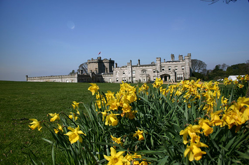
Dundas Castle
We recently visited Dundas Castle – located in South Queensferry this castle is now the stately home of Sir Jack and Lady Stewart-Clark, but was formerly a home of Clan Dundas
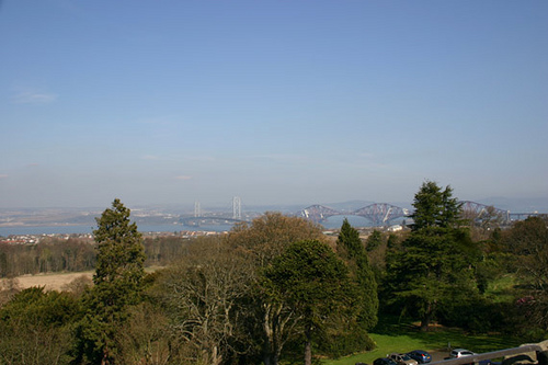
view of Forth Bridge from Dundas Castle
The commanding views over the Forth made this castle an important part of Scotland’s defence during the Second World War. In 1938 a German Luftwaffe raid on the Forth Road Bridge caused alarm and protection for this vital bridge was put into place, barrage balloons were floated around the bridge and an army headquarters was set up at Dundas Castle. For five long years soldier’s occupied Dundas Castle.
If you climb the steep stairs of the tower you will not only see amazing views but also messages left by the soldiers in the lead piping on the roof. Scratched over the long hours keeping watch on the incrediably important Forth Road Bridge.
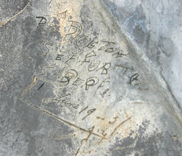
Writing in the lead piping
The post Messages from WW2 soldiers at Dundas Castle appeared first on ScotClans | Scottish Clans.
]]>